- Services
- Project Management
- Engineering Survey
- Way Leave Survey
- Hard & Soft Landscaping Works
- Cadastrial Survey
- Boundary Alignment
- Mutation Survey
- Power Lines Construction
- Cartographic Works
- B.O.Q preparations
- Electrical works
- Property Management and Real Estate Agency
- Renovation and Remodeling Services
- Design Work
- General Construction Contractors
Contact Our Office
Please feel free to contact us. We will get back to you with 1-2 business days. Or just call us now.
CALL US: +254 722 253 299
CALL US: +254 711 772 727
MAIL US: enquiries@geo-smart.co.ke
MAIL US: geosmart2016@gmail.com
Way Leave Survey
A Topographical Survey is an accurate depiction of an object, a feature or site (e.g. property, area of land or a defined boundary) which is scaled and detailed according to the spatial considerations (coordinates, bearings, distances etc.) and is the summary of the on-site data capture processes. Topographical survey determines the location of natural and man-made features (such as buildings, improvements, fences, land contours, trees, streams, etc.) of the land along with its elevations. Topographic survey provides you with the exact figures of the size, height, position of the different changes that have occurred in course of time with regard to their presence of their natural existence. Sometimes, these surveys are also used for the formulation of an optimal plan for drainage, ditches, grading and other features. A Topographic Map is used to depict terrain relief showing ground elevation, usually through either contour lines or spot elevations.
Procedure for Way Leave Survey
The purpose of topo survey is to gather spatial information relating to the site (natural and man-made land features). This can often be related to national Ordnance Survey grid and datum information (often using GPS) and is surveyed by point. It is typically accepted that points are positioned in three dimensions-3D (x,y and z) which facilitates ground modelling and visualisations to be produced from the topographical survey. During detailed topographical surveys, additional information may often be integrated into topo surveys which helps a design team in taking account of the necessary and relevant site constraints such as accuracy, nature of terrain etc. This can also include site sections through particularly diverse gradient transects, spot heights of surrounding land and site features, i.e. neighbouring properties to assess overlooking, underground utilities information (from radar tracing and integrating utility records data).
Requirements for Topographical Surveys
1. Geodetic or 1:50,000 topo maps showing the Ground Control Points, Benchmarks or spot heights as established by Survey of Kenya etc;
2. High precison and calibrated survey equipment e.g. a total station, level machine, drone or a GNSS (RTK or geodetic);
3. A CAD Drafting software such as AutoCAD Civil 3D or Spatial analysis software e.g. ArcGIS or QGIS;
4. A registered Surveyor (from Institution of Surveyors of Kenya-ISK) or a licensed Surveyor (from Licensed Surveyors Board-LSB);
5. Some projects may require bush clearing done prior to executing topo survey work. This is important to ensure there is no obstruction during survey work.
Methods for Topographical Surveys
i. Geographical Information Systems (GIS): GIS has contributed a lot to the mapping revolution in 21st century. GIS makes it possible to combine layers of digital data from different sources and to manipulate and analyze how the different layers relate to each other. The process of converting the three (3D) topographic maps to digital form involves raster to vector conversion using CAD-based software such as AutoCAD.
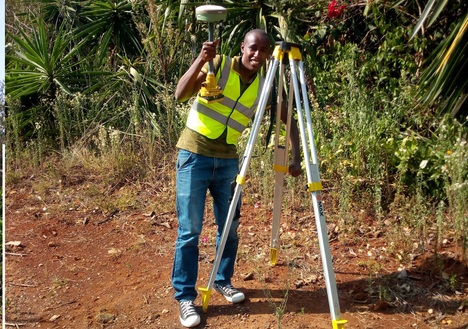
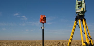
ii. Total Station or Theodolite Surveys: The total ststion or theodolite measures the angles, and the distances are measured with either a steel measuring tape or, more commonly, an electronic distance meter (EDM). An EDM can measure great distances (several kilometres) very quickly and accurately. It measures distance with the usage of light and radio waves. Its development was a milestone in survey measurement methods.Topographical Survey Services in Kenya
iii. GNSS or GPS: A constellation of Global Navigation Satellite System (GNSS) or Global Positioning System (GPS) satellites orbiting the earth is used to determine the position(s) of GPS ground receivers as they are moved from one point to another. The collected data may either be processed in the office to produce GPS receiver positions (control surveys) or in the field to give the field surveyor immediate receiver positions (real time GPS surveys) for use for example in construction or for subdivision layout surveys.
iv. LiDAR Technology: Airborne LIDAR (Light Detection And Ranging) systems can produce extremely accurate elevation models for terrain (even measuring ground elevation through trees), while offering a quick and efficient method of surveying terrain that is not easily accessible. LiDAR, like the similar radar technology (which uses radio waves instead of light), determines the range to an object by measuring the time delay between transmission of a pulse and detection of the reflected signal.
v. Photogrammetry: In this method, stereographic pairs of photographs are used to indirectly measure objects on the ground and then calculate point coordinates and height differences.
vi. UAV or Drone Technology: Unmanned Aerial Vehicles popularly known as drones have become one of the greatest innovations in aerial mapping realm. Drones can be used to execute topographical surveys at varying accuracies. Drones fly at height of approximately 100 to 150 metres above the ground level capturing images at a resolution of 3cm. The images can then be processed to create DSMs, DEMs and topographical maps with contours.

Certified Contractor

Dedicated Team Members
Topographical Survey Outputs or Products?
We have served global clientele and at Geo-Smart Engineering, we understand high standards. We adhere to quality policy and target customer satisfaction. These have been the underlying factors for our success history. We are highly efficient in Way Leave Survey and can serve you the best!
Field Survey Observation data showing observed coordinates and their accuracy e.g. in excel or a spreadsheet;
A topographical map drawn to scale e.g. 1:500 or 1:1000 or 1:2500 depending on the client need and the scope of work;
Longitudinal and cross sectional profiles for further construction and engineering design work e.g. sewerline or pipeline laying out;
Other information such as field photos, accuracy sheet, survey adjustment computations incase of Static Survey etc.
A fieldwork and data processing report indicating the overall approach adopted during fieldwork and data analysis;